Author: Zaffos

How not to forget the West’s past atrocities

How not to forget the West’s past atrocities

Sand Creek Massacre National Historic Site (Photo: National Park Service)

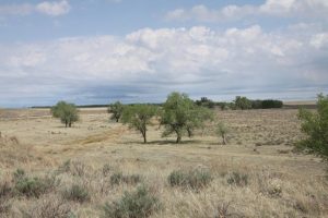
I stood on a bluff in southeastern Colorado, overlooking the lonesome prairie, 180 miles southeast of Denver. Bare cottonwoods lined the dry bed of Big Sandy Creek. Otherwise, there was nothing but grass, earth, rocks and sky. The only sounds that November day were the wind and the singing of LaForce “Lee” Lonely Bear, a Northern Cheyenne spiritual adviser.

This was the site of the notorious Sand Creek Massacre. At dawn on Nov. 29, 1864, a 675-man Colorado militia, led by Col. John Chivington, a Methodist minister, attacked a small, peaceful village of Cheyenne and Arapaho camped along the creek. Without provocation, the militia charged and killed at least 150 Indians, mostly women and children. According to militiamen and survivors, soldiers chased unarmed Indians down the creek bed, raped and bayoneted women, hacked off limbs and genitals. Cheyenne Chief White Antelope was scalped and mutilated as he pleaded for peace. The Cheyenne say that White Antelope repeated his final journey song as he lay dying: “All my relations, remember / Only the rocks on earth stay forever.”

Braided Hair, Lone Bear and the others who brought me to the site in 2005 had been working to change that, partly by establishing Sand Creek as a national historic site managed by the National Park Service. Along with other Cheyenne and Arapaho tribes, they envisioned it becoming a place of remembrance and healing for their own people and the nation. “So the history may live on,” Lone Bear told me.

“How not to forget the West’s past atrocities”

High Country News, March 7, 2016

How some Western cities are leading on climate action

How some Western cities are leading on climate action

This community solar farm in Fort Collins will reduce CO2 emissions by 39,500 tons over its 50-year lifetime (Photo courtesy: Poudre Valley REA)

A college town of 155,000 people known for its beers and bike lanes, Fort Collins, Colorado, adopted an ambitious climate action plan this past spring to cut its carbon emissions 80 percent by 2030 and be carbon-neutral by 2050. The initiative lacks worldwide reach, but it outpaces the goals of the Paris pact, with an aggressive timeline matched by only a few other cities, including Seattle, Copenhagen and Sydney. Even as world leaders have dragged their feet, taking 21 frustrating years and annual conferences to finally set some climate goals,  cities like Fort Collins have charged ahead, determined to drastically reduce greenhouse gas emissions to avoid ecological catastrophe. 

The city passed its first action plan and started measuring its emissions in 1999. With its purple political background and acknowledged need to wean itself from coal power, Fort Collins could serve as a blueprint for other, similarly sized communities.

Even though the city’s last four mayors have all leaned to the right politically, they have all generally supported climate action. Current Mayor Wade Troxell, a Republican, was among 27 mayors who penned a letter to President Obama this June, asking him to “fight for the strongest possible climate agreement” in Paris and “for federal action to establish binding national greenhouse gas emissions reductions here at home.” While other politically fraught issues, from a city fracking moratorium to relaxed public-nudity laws, have recently split the council, it unanimously approved the aggressive new climate-action plan this spring.

“How some Western cities are leading on climate action”

High Country News, January 13, 2016

Highway injustice in Denver’s Latino neighborhoods

Highway injustice in Denver’s Latino neighborhoods

A rendition of the highway cover alternative for I-70 in Denver that would add a new park space near Swansea Elementary School. (Courtesy Colorado Department of Transportation)

One of Colorado’s most congested highways, I-70 East badly needs repairs or replacement. But the six-lane highway also cuts off Latino neighborhoods’ access to other parts of the city, and its air pollution contributes to some of Denver’s highest rates of asthma and cardiovascular disease.

Neighborhood residents fear that plans to replace it with a larger, partially belowground highway could just exacerbate their problems. What’s more, they claim planners are ignoring a cheaper, community-friendly alternative.

“Highway injustice in Denver’s Latino neighborhoods”

High Country News, December 21, 2015

How a plan to save southeastern Colorado went off the rails

How a plan to save southeastern Colorado went off the rails

Steve Wooten and R.C. Patterson at the Mustang Pavilion, in Kim, Colorado (JZ)

About a decade ago, the Army proposed a massive $1 billion expansion of the site, up to 7 million acres. It would have involved seizing private lands — through a legal process called eminent domain — across most of the southeastern corner of the state, an area bigger than Maryland, displacing more than 17,000 people.

A feisty group of local ranchers, farmers, businesses and officials sprang up in response. Wooten became vice president of the Piñon Canyon Opposition Coalition, which allied with university scholars and conservation groups. They surveyed the area and identified its rare and impressive natural and historical resources, including neo-tropic bird migration stopovers and centuries-old Native, Hispanic and Anglo artifacts. In late 2013, congressional representatives from Colorado convinced the military to withdraw the waiver allowing the expansion. Somehow, this ragtag group of ranchers, farmers and nature-lovers had defeated the world’s largest military.

But even as they celebrated their victory, Wooten saw other challenges looming: a long-lasting drought, an up-and-down livestock market, struggling ranches and dying downtowns. “We see our young people not coming back from college and opening new businesses here because they don’t see an economic chance. We have more attrition than we have growth,” Wooten says. “That should be a wakeup call.”

Wooten’s family sells landscaping stones, raises horses, and opens its lands to hunting, art workshops and “guest ranching” to get by. That led him and others to embrace the idea of “heritage tourism” — bringing in visitors who want to experience an area’s natural and human history. Perhaps they could preserve the region’s resources, avert future Army expansions, bring in money and even attract new residents.

“My thought is, how do you create a community that is economically stronger and more diversified and balanced, and I saw a heritage area as a tool to help us do that,” says Wooten.

He had no idea that garnering the necessary support would make defeating the U.S. Army seem almost easy in comparison.

“How a plan to save southeastern Colorado went off the rails”

High Country News, November 23, 2015

Tar Sands Mining Hits the American West

Tar Sands Mining Hits the American West

Protestors with Peaceful Uprising at the test pit of the planned Utah tar sands mine (via Peaceful Uprising)

Tar sands, also known as oil sands, require intensive processing to produce usable crude—it can take two tons of sand to produce just one barrel of oil. The expense of extracting and refining that oil (and the pollution the process entails) has historically kept most of it in the ground. However, beginning in 2000, rising oil prices and calls for North American energy independence set off a tar sands boom in Alberta (not to mention an endless debate in this country about the Keystone XL pipeline, which would carry Alberta’s tar sands oil to the States). Fifteen years later the industry has cleared or degraded nearly two million acres of boreal forest, created toxic tailings ponds and other waste, and become Canada’s fastest-growing greenhouse gas emitter. And now it’s looking south. 

In July 2015, Utah’s Division of Oil, Gas, and Mining issued a permit clearing the way for the opening of this country’s first commercial tar sands mine amid eastern Utah’s Tavaputs Plateau, which sits atop an estimated 20 billion to 32 billion barrels of recoverable oil. 

At a moment of growing public consensus that it’s time to move away from dirty energy, the decision to open up Utah canyon country to the development of what many consider the dirtiest energy source of all sends a decidedly contradictory—if not perverse—message. “If the fuels are made available,” says Dan Mayhew, the chair of the Sierra Club’s Utah chapter, “the amount of carbon that could be emitted is staggering”—as much as 48 billion metric tons just from the oil shale, according to a Sierra Club estimate. 

“Tar Sands Mining Hits the American West”

Audubon Magazine, September/October 2015

The BLM Just Sold More Leases on the Pawnee — and Environmentalists Say That’s for the Birds

The BLM Just Sold More Leases on the Pawnee — and Environmentalists Say That’s for the Birds

An oil rig on the Pawnee National Grassland, Colorado (Photo via US Forest Service)

An hour’s drive northeast of Denver and encompassing an area twice the size of the city, the Pawnee National Grassland’s whopping diversity of songbirds and raptors has earned the area a reputation as a birder’s paradise. Some people drive hundreds of miles and fly in from around the world each summer to view mountain plovers and burrowing owls, lark buntings and McCowns’s longspurs.

But in recent years, birders have begun spotting a whole other family of beasts nesting in the Pawnee. Oil and gas drilling has skyrocketed in the area over the past decade, part of a nationwide industry boom that has tapped underground shale formations up and down Colorado’s Front Range. Just as he tracks the birds he sees, Gary Lefko notes the pump jacks and well pads that have sprung up on the grassland. On some outings, he has seen dozens of tall blue flames from flare stacks, burning off unused methane and glowing in the half dark in and around the Pawnee. Along state highway 14, which runs through the grassland, Lefko and his wife count the tank batteries — silos that store oil — and other industry equipment that keeps filling in pieces of the prairie. “There’s more every time,” Lefko says.

Amid the massive grassland, the industry impacts may not seem like much. The Pawnee still mostly looks like an empty, undeveloped canvas of greens and browns. But each new well pad and scraped patch of ground and every truck that rumbles along and kicks up dust from the dirt roads affects this subtly beautiful ecosystem. The piecemeal energy development destroys bird and wildlife habitat and alters the shortgrass prairie in ways that even scientists don’t fully understand. Some compare the impacts to death by a thousand cuts for the flora and fauna of grasslands already in decline.

“The BLM Just Sold More Leases on the Pawnee — and Environmentalists Say That’s for the Birds”

Westword, July 28, 2015

Can leasing irrigation water keep Colorado farms alive?

Can leasing irrigation water keep Colorado farms alive?

The Arkansas River, swollen by heavy spring rains in 2015, in rural Crowley County, Colorado (Photo via Wikimedia Commons)

Colorado cities have siphoned more than 100,000 acre-feet of ag water — enough for about 200,000 homes — from the Arkansas River Basin alone since the 1970s. In Crowley County, farming has vanished, school-class sizes are half what they were 50 years ago, and tumbleweeds from dried-up fields pile up along fences and block roads. “That’s what they’re stuck with, because there’s no more water,” says John Schweizer, a farmer and rancher in neighboring Otero County. “It’s gone forever.”

Schweizer is president of the 35-mile-long Catlin Canal, which irrigates about 18,000 acres of farms. He’s hoping that the trial run of something called the Arkansas Valley Super Ditch will save the basin’s remaining communities and farms. The initiative is not actually a big ditch, but rather a scheme that allows six of the valley’s irrigation canals to pool their water rights and temporarily lease them to cities. Starting in March, five Catlin irrigators “leased” a total of 500 acre-feet of water, which would normally supply their fields, to nearby Fowler and the cities of Fountain and Security, 80 miles away. Under the agreement, communities can use the farm water to supply homes and recharge wells for up to three years out of every decade. During those years, the irrigators will have to fallow, or rest, some fields, yet will still be able to earn money from the water itself and farm the rest of their land.

Supporters believe the Super Ditch could eventually enable farms and cities to share up to 10,000 acre-feet of water. “We look at leasing water just like raising a crop,” says Schweizer, who is avoiding any potential conflict of interest by keeping his own farm out of the pilot. “It is a source of income, and anybody who’s doing that can have the water next year if they want to farm with it. And they are still in the valley, so the community stays viable.”

Statewide, cities have acquired at least 191,000 acre-feet of agricultural water, eliminating farming and ranching on millions of acres. Water managers estimate Colorado could lose up to 700,000 more acres by 2050. Like Schweizer, officials consider water leasing, also called lease-fallowing or rotational fallowing, a promising way to slow that loss while satisfying urban thirst, particularly since alternatives like new dams and other big water-development projects face regulatory hurdles and environmentalist opposition. Colorado’s draft water plan suggests the state could meet up to 50,000 acre-feet of its future water needs — and avoid more buy-and-dry — through such water-sharing deals.

“Can leasing irrigation water keep Colorado farms alive?”

High Country News, June 8, 2015

Counties use a ‘coordination’ clause to fight the feds

Counties use a ‘coordination’ clause to fight the feds

Farm in the Bitterroot Valley, with the Bitterroot National Forest beyond, in Ravalli County, Montana (Via Wikimedia Commons)

In 2011, Ravalli County (Montana) Commissioner Suzy Foss asked American Stewards of Liberty for help. The Texas-based nonprofit trains local governments to use “coordination,” an often-overlooked provision in key environmental laws that govern land management. The Federal Land Policy and Management Act specifically directs the Bureau of Land Management to “coordinate the land use inventory, planning, and management activities” with states, local governments and tribes. The National Forest Management Act includes similar language for the Forest Service.

According to American Stewards Executive Director Margaret Byfield, coordination means that federal agencies must involve counties and states in planning and give them an “equal position at the negotiating table” for decision-making. “It is,” she says, “pretty straightforward.” The nonprofit says over 100 local governments have invoked coordination to fight land-use restrictions since 2006.

Many groups, including environmentalists, try to influence land management with scientific research and alternative management proposals, but policy experts say that the coordination movement has a distinctly anti-federal government flavor — a Sagebrush Rebellion in bureaucratic clothing, with links to state efforts to take over federal lands. Coordination proponents are “essentially arguing a county would have veto authority on federal land decisions,” says Martin Nie, director of the Bolle Center for People and Forests at the University of Montana. And federal officials, who interpret “coordination” very differently, fear it’s stoking more conflicts than it resolves by misinforming locals.

But though critics, including federal land managers, may dismiss American Stewards’ interpretation of coordination, it’s gaining traction among state and U.S. lawmakers and Western governors. “It has no legal basis, but it’s as much about trying to frame things politically,” Nie says.These proposals are pushing way, way outside the mainstream.”

“Counties use a ‘coordination’ clause to fight the feds “

High Country News, May 11, 2015

In the Sagebrush Marketplace, A New Way to Protect Species

In the Sagebrush Marketplace, A New Way to Protect Species

Rancher T. Wright Dickinson surveys sage grouse habitat on his cattle’s summer range. (JZ)

Cows aren’t the only animals on the move this time of year. Greater sage grouse gather in open patches of sagebrush, known as leks, where the male birds perform their noisy strutting display to attract female mates. Afterward, the birds disperse into nearby wetter meadows to nest and hatch their chicks. In winter, the birds find sheltered draws where they survive eating sagebrush leaves.

Greater sage grouse follow that annual routine in 11 Western states on more than 78 million acres. But the species has declined by 45 to 80 percent in recent decades due to sagebrush loss and fragmentation caused by overgrazing, subdivision and sprawl, booming energy development, and other factors, such as predation and disease. The U.S. Fish and Wildlife Service is now considering the grouse to be listed under the Endangered Species Act. Such a move could hinder ranching, oil and gas drilling, and wind and solar energy across the American West, potentially costing up to $5.6 billion in annual economic activity and up to $262 million in annual state and local revenue.

Rancher T. Wright Dickinson isn’t interested in federal mandates. Instead, he is backing a novel approach to conservation through a so-called “sagebrush marketplace.” The Colorado Habitat Exchange aims to help sage grouse by allowing energy companies and developers that unavoidably fragment or degrade grouse habitat to purchase “credits” from landowners, such as Dickinson, to mitigate, or offset, their impacts. In return, the landowners agree to protect and restore critical wintering, breeding, and nesting grounds for the bird.

Dickinson and other rural landowners have their own hopes: that the exchange, by putting a price tag on sagebrush habitat, can help keep the sage grouse off the endangered species list, while providing ranchers with supplemental income for good land stewardship. “The exchange is creating a unit of measure for sage grouse, no different than my carrying capacity for cows,” Dickinson says. “Contracts are a methodology that landowners and industry understand.”

“In the Sagebrush Marketplace, A New Way to Protect Species”

Yale Environment 360, April 2, 2015

Red States Are Getting a New Shade of Redder

Red States Are Getting a New Shade of Redder

A tractor works the fields in the Great Plains (U.S. Agricultural Research Service)

Climate models project that Rep. Cory Gardner’s current House district—along with much of the food-producing Great Plains and Corn Belt—will experience the country’s most drastic temperature and precipitation changes in the coming years. Gardner’s home turf, one of the 10 largest congressional districts in terms of agricultural area, will likely face a temperature increase of more than 8 degrees Fahrenheit and a more than 9 percent drop-off in precipitation by 2100—among the most extreme projections for the country.

That’s according to analysis from a forthcoming peer-reviewed study by Brady Allred of the University of Montana and colleagues. Allred’s study looked at political representation, agricultural and natural-resources land cover, and projected climate disruptions across the nation’s 435 U.S. House districts. The researchers discovered that the districts with the most agriculture and natural resources are predominantly represented by Republicans who generally deny the science of global warming. Those districts also likely face the most severe climate changes.

Allred says the findings highlight a “disconnect between vulnerability [to climate change] and the current political rhetoric.”

The disconnect isn’t just depressing news for climate-conscious voters in other parts of the country. The failure to act on climate issues could devastate the nation’s breadbasket. Climate change could harm corn, soy, wheat, and cattle production, affecting U.S. and global food supplies. In other words, the effects of political polarization and Republican aversion to climate action could harm everyone.

“Red States Are Getting a New Shade of Redder”

Slate, December 11, 2014